|
 |
|
Discovering Wisconsin Waterfalls,
Hiking & Travel
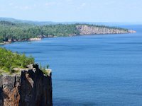
- South Shore Lake Superior Circle Tour

Amnicon Falls
near Superior Wisconsin
Wisconsin Waterfalls on this Page:
Manitou Falls (big and little)
Amnicon Falls
Copper Falls
Morgan Falls
Potato Falls
Superior Falls
Saxon Falls
Potato Falls in Fall Color
Red Granite Falls in Fall Color
Our waterfall trail along the Lake Superior watershed begins south of Superior, Wisconsin at Pattison State Park, a Wisconsin campground with hiking trails and the state's highest water fall. The route then heads back north and a little east of Superior to Amnicon Falls State Park. . . then to Bayfield, Ashland and Hurley. Several impresive water falls exist along this route.

Camping Around Lake Superior Campgrounds in Bayfield Area
Waterfalls in Wisconsin
Lake Superior Watershed 
) Manitou Falls . . .
Manitou Falls . . .
Is about 15 miles south of Duluth-Superior and located in Wisconsin's Pattison State Park. Big Manitou Falls, to the right, is Wisconsin's highest waterfall at about 165 feet. While the falls is impressive, the park needs to cut a trail (or construct a staircase) down the side of the canyon to allow a closer view.
)
We actually liked Little Manitou Falls better. A scenic hiking trail leads to it.
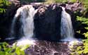
) Amnicon Falls . . .
Amnicon Falls . . .
)
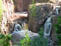
Is about 15 miles east of Duluth-Superior and located in the Wisconsin state park of the same name. A pretty little park with nice picnic areas. The river has several cascades in addition to the waterfalls. The water levels were down in these pictures as it was the fall of the year.
)
)
Some scenes upstream and downstream of the covered bridge.
![]() Go Here for more Pictures and information on Amnicon Falls State Park.
Go Here for more Pictures and information on Amnicon Falls State Park.
) Morgan Falls is about 20 miles south of Ashland, Wisconsin. It's a pretty little falls that empties into a pool that begins Morgan Creek. > > >
Morgan Falls is about 20 miles south of Ashland, Wisconsin. It's a pretty little falls that empties into a pool that begins Morgan Creek. > > >
A much more enthusaistic hike can be had by taking the side trail to St. Peters Dome. It looks north towards the Bayfield Peninsula. On a clear day you can see Lake Superior.
)
Copper Falls. Just north and east of Morgan Falls near Mellen, Wisconsin is Copper Falls State Park, which has two waterfalls and some decent hiking trails. (Pets are not allowed on the main falls trail, but are OK on one of the other trails.) See more information here.
![]() See Red Granite Falls in Fall Color
See Red Granite Falls in Fall Color
 Wisconsin Parks Pet Unfriendly Policy.
This brings up a bone we have to pick with Wisconsin parks officials. We've traveled extensively in state and provencial parks - in Alaska, Minnesota, Michigan, Alberta, British Columbia, Ontario to name a few - and rarely - if ever - have we encountered bans against dogs on the hiking trails. And in all the mega-miles of hiking, I have only seen one incident of "doggie poop" on a trail. Apparently the people who run Wisconsin parks don't understand that hikers who have dogs as hiking companions make sure they aren't a nuisance to others.

 More Wisconsin Waterfalls
)
)
Potato Falls . . .About 15 miles east of Ashland near the town of Gurney, there are two sets of falls on the Potato River, the last one dropping about 90 feet. The fall waterflow was down so I am looking forward to catching this one again in the spring.
![]()
![]() See some impressive Potato Falls Photos during Fall Color time
See some impressive Potato Falls Photos during Fall Color time
)
Superior Falls . . . is on the Montreal River that forms the border between Wisconsin and Michigan's Upper Peninsula. It's a short paddle from Lake Superior and is listed as a 90 footer. The hiking trail past the power plant is rather unscenic. For the fall of the year, the Montreal still carried alot of water, which explains the power generating station.
)
Saxon Falls . . . is upstream a few miles from Superior Falls and on the Montreal River and another 90 footer. It is also near a power plant, but there is no hiking trail to the falls. I had to play mountain goat working my way down the canyon walls to get this shot.
Waterfalls in the Michigan Upper Peninsula Waterfalls Western UP: |
Waterfalls along North Shore Page 1: |
SuperiorTrails.com - Reinhold Development - 2023

- Lake Superior Circle Tour
- Wisconsin Travel
- Wisconsin Travel Guide
- Bayfield WI
- Big Top Chautauqua
- Cornucopia WI
- Apostle Islands
- Madeline Island
- Big Bay State Park
- Amnicon Falls Park
- Ashland, WI
- Copper Falls State Park
- Fall Color Scenic Drives
- Lake Superior Ice Caves
- Superior, WI
- Superior Burgers & Pizza
- Best Superior Wi Pubs
- Superior Wi Dragonboat Race
- Washburn, WI
- Wisconsin Golf
- Wisconsin Travel Map
- Wisconsin Water Falls
- Wisconsin Winter Events
- Wisconsin Fall Color
- Minnesota North Shore
- Ontario Travel
- Michigan Upper Peninsula
- Travel Resources
- Agates & Beach Rocks
- About Us

Bayfield Holiday Events & Activities
Duluth Holiday Events and Fun.
Winter - Michigan UP
Winter - Wisconsin Winter - Minnesota
Winter - Sault Ste Marie.
 See our guide to interesting and fun things to see and do on Madeline Island.
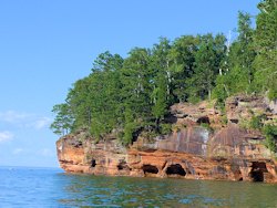
See photos from our recent Apostle Islands
Sea Caves cruise.
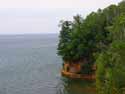
Apostle Islands Sea Caves Hiking Trail is about a 3.5 mile round trip from Meyers Beach to the Bayfield Sea Caves
Lake Superior Travel Directories
Minnesota Travel
Wisconsin Travel
Upper Peninsula
Ontario Travel

Bayfield Apple Festival is Northern Wisconsin's favorite fall festival.

Rainbow Falls, Rossport, Ontario
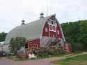
Orchard Touring
Take a scenic drive of
farms and orchards in the Bayfield area.
![]()

Hotel, Motel Lodging
Ashland, Superior, Ironwood, Wisconsin South Shore
![]()

Lake Superior Circle Tour Road Map & Guide to Travel Attractions around Lake Superior.

Duluth's amazing Bentleyville Duluth Christmas Lights Village.
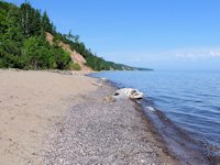
How to recognize Lake Superior Agates and Beach Rocks.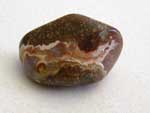
Best Wisconsin Lake Superior Agate Beaches
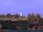
See the lighthouses on an Apostle Islands Cruise.
Copper Falls State Park
is near Mellen, Wisconsin.
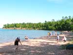
Enjoying the great swimming Beach Big Bay State Park on Madeline Island.
Apostle Islands Sea Caves Hiking Trail is about a 3.5 mile round trip from Meyers Beach.

See our
Reviews of Best Wisconsin golf courses on Lake Superior.