 |
 |
|
 Western Upper Peninsula Michigan -
Water Falls,
Hiking & Camping
Western Upper Peninsula Michigan -
Water Falls,
Hiking & Camping
- South Shore Lake Superior Circle Tour
Some of the UP's most impressive waterfalls are located within 50 miles of Wisconsin in the western end of the Upper Peninsula.
Upper Michigan Peninsula
Waterfall Directory
Western UP Waterfalls:
(see pictures below)
Presque Isle Waterfalls
Manabezho Falls
Manido Falls
Nawadaha Falls
Black River Waterfalls
Rainbow Falls
Sandstone Falls
Potawatomi Falls
Gorge Falls
Conglomerate Falls
Central UP Waterfalls:
Marquette - Sault Ste. Marie Waterfalls:
Laughing Whitefish Falls
Munising Falls
Miners Falls
Sable Falls
Upper Tahquamenon Falls
Lower Tahquamenon Falls
Circle Tour Travel Planner
UP Camping Directory
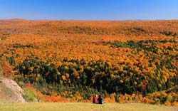
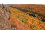
UP Color Tour
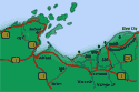
Coming from Wisconsin, heading on Highway 2 east out of Ashland, Wisconsin towards the Michigan Upper Peninsula, the road eventually leaves the lakeshore. You can rejoin the lake by taking Wisconsin Hwy 122 north near the berg of Saxon. That road morphes into Michigan 505 when you cross the state line - which is the Montreal River. (There are two impressive waterfalls, Saxon and Superior Falls, on the Montreal River - see pictures on the Wisconsin Waterfall Directory page). Continue on 505 climbing the bluffs past the Little Girls Point campground and you'll soon arrive in Ironwood, Michigan. Then rejoin Highway 2 and head east towards Bessemer. Look for the sign for the Black River Scenic Byway on the outskirts of Bessemer. Great hiking, waterfalls, and scenery are waiting!
After visiting Black River Harbor you can return to Highway 2 and continue east towards Wakefield, Michigan. About a mile north of town on Michigan 28 you encounter the road to Presque Isle Scenic Recreation Area - more impressive waterfalls, hiking, camping, and scenery.
)
Waterfalls Black River National Scenic Byway
The Black River begins about 30 miles south of here in Wisconsin, heads north into Michigan while dropping over a 1000 feet in such a short distance! The last few hundred feet of this drop are part of this national parkway that includes hiking trails to several falls plus a nice camp ground and picnic area near the harbor. The North Country Hiking Trail bisects the parkway as well.
Although water levels were down, the falls and surrounding scenery were well worth the trip. [See our links to more pictures of the falls during two other trips when water levels were higher]
)
)
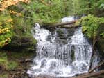
Rainbow (left) Sandstone Falls (right) After our hike, I discovered Rainbow Falls - on the left - can be better viewed from a trail on the other side of the river - which would have been a nicer shot of the complete falls. Hans and JO enjoyed the close-up view of Sandstone Falls >>>

See our Video of Rainbow Falls
![]() More Rainbow Falls pictures
More Rainbow Falls pictures
![]() Rainbow Falls - Fall Color
Rainbow Falls - Fall Color
)
)
)
)
Gorge Falls (left) Conglomerate Falls (right)
Geology buffs will enjoy this hiking this area, identifying the traces of volcanic upheaval from eons ago.
After this hike, I think I now know can recognize greenstone and conglomerate rock!!
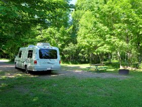
Black River Harbor & Campground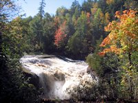
Fall Color Tour, Black River: waterfalls, camping, hiking
One of the undiscovered jewels along the UPs Lake Superior shoreline. Nice campground, terrific waterfalls, good hiking trails, spacious picnic area.
![]()
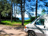
Presque Isle River Scenic Recreation Area - Waterfalls & Hiking
Located at the extreme western end of Michigan's Porcupine Mountain State Park, the Presque Isle river runs parallel to and about 15 miles east of the Black River. Take Highway 28 north out of Wakefield for about a mile or two until you intersect with County Road 519. Presque Isle harbor is about 14 miles.
As with the Black River area, there are miles of great hiking trails and scenery.
The campground and picnic area is more rustic than what we found at the Black River campground. In 2002 they were having trouble with a contaminated water supply and at that time lacked the funds to install the necessary filtration systems. So plan to bring in your own fresh water supply.
Unfortunately water levels were down quite a bit so the falls were a shrunken version of their greatness! But still neat. But on a subsequent trip we did find higher water levels.
)
)
)
)
Manabezho Falls (left) Manido Falls (right)
There are sturdy boardwalks and stairs along the river bank . . . as well as some viewing areas that are handicapped accessable.
![]() Porcupine Mountain State Park & Campground
Porcupine Mountain State Park & Campground
 The "Porkies" have some great hiking trails and scenic areas . . . plus camping, waterfalls, rivers, and Lake Superior beaches. You could easily spend a week there exploring what it has to offer and still leave lots for future visits.
![]()
Tahquamenon Falls State Park Campground & Waterfalls
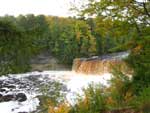 Tahquamenon is a large (40,000 acres, 13 miles long) state park with two widely separated camping areas. The highlight of the park is the Upper Falls, almost a 50 foot drop and stretching across 200 feet. At times as much as 50,000 gallons of water per second cascade down.
See waterfall pictures and more information on Tahquamenon Falls State Park.
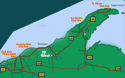
Michigan Upper Peninsula Lake Superior Circle Drive
![]() Going east towards Munising and Pictured Rocks . . . More waterfalls and hiking pages from the Keweenaw Peninsula through Tahquemenon Falls to Sault Ste. Marie.
Going east towards Munising and Pictured Rocks . . . More waterfalls and hiking pages from the Keweenaw Peninsula through Tahquemenon Falls to Sault Ste. Marie.
![]() Michigan UP Copper Harbor & Keweenaw Peninsula
Michigan UP Copper Harbor & Keweenaw Peninsula
![]() Ontonagon & Porcupine Mountains State Park
Ontonagon & Porcupine Mountains State Park
WI South Shore Wisconin Lake Superior Waterfalls: |
Minnesota North Shore North Shore Page 1: |
SuperiorTrails.com - Reinhold Development - 2023

-
Upper Peninsula Michigan
- Michigan Upper Peninsula Travel
- Baraga, MI
- Black River Harbor Campground & Waterfalls
- Fall Color Black River Scenic Byway
- Copper Harbor, MI
- Grand Marais, MI
- Keweenaw Peninsula
- Keweenaw Peninsula Scenic Drive
- Keweenaw Fall Color
- Hancock-Houghton, MI
- Ironwood Michigan
- Marquette, MI
- Best Restaurants Marquette
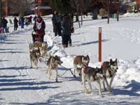
- UP 200 Sled Dog Race
- Marquette to Sault Ste Marie
- Munising, MI
- Munising Ski Snowshoe
- Pictured Rocks National Park
- Porcupine Mountains State Wilderness Park
- Sault Sainte Marie
- Tahquamenon Falls State Park
- The Soo Locks
- Upper Peninsula Camping
- Upper Peninsula Waterfalls
- Upper Peninsula Winter Events
- Travel Map Eastern Upper Peninsula
- Travel Map Western Upper Peninsula
- Fall Color Scenic Drives
- Winter Events Upper Peninsula
- Upper Peninsula Golf Courses
Winter - Michigan UP
Winter - Wisconsin Winter - Minnesota
Winter - Sault Ste Marie.
Best Upper Peninsula Campgrounds
Lake Superior Camping
& Campground Directory
Best Camping along Lake Superior.
Tahquamenon Falls State Park and Waterfalls.
Copper Harbor and Brockaway Mountain
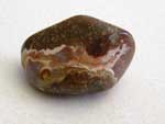
Identifying Lake Superior Agates and Beach Rocks
Michigan Upper Peninsula Waterfalls
![]()
Travel Information |
Motels & Hotel Directory |

Lake Superior Circle Tour Road Map & Guide to Travel Attractions around Lake Superior.
Identifying Lake Superior Agates and Beach Rocks.
Black River Harbor
Scenic Byway - Fall Color.
Best Rock Picking and Agate Hunting Beaches in the Upper Peninsula. 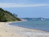
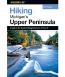
Hiking Michigan's Upper Peninsula
Eric Hansen's guide to UP hiking is well respected in hiking circles. This guide includes profiles on some terrific off-the-beaten path hiking trails. [More info]
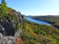
Porcupine Mountains Lake of the Clouds
Porcupine Mountains State Park was voted #2 Best State Park in the U.S.


See our Reviews of Michigan Upper Peninsula Golf Courses around Lake Superior.