 |
 |
|
Pictured Rocks National Lakeshore Park &
Grand Marias, Michigan
Waterfalls,
Hiking & Camping
- South Shore Lake Superior Circle Tour

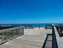
Grand Marais beach looking west towards Grand Sable Dunes in
Pictured Rocks National Park
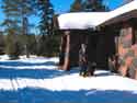
The village of Grand Marais, Michigan anchors the east end of Pictured Rocks National Lakeshore Park. Its Woodland Park campground is a popular destination for RV owners who want to do some hiking and exploration in the eastern end of the park. The campground's beach also happens to be one the most popular beaches for rock picking and agate hunting - as the figures in the above pictures were doing.
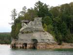
Pictured Rocks National Park offers some of the midwest's finest hiking, picturesque camping and picnicing on the shores of Lake Superior, beautiful waterfalls, and other scenic attractions including its namesake "pictured rocks." The park can be accessed from either Munising or Grand Marais, Michigan. Both entrances offer park visitor centers to assist you in exploring the park.
Pictured Rocks Attractions - near the Grand Marais entrance - Sable Falls, Grand Sable Dunes , Au Sable Lighthouse
)
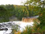
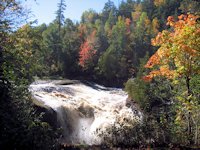
< < < Sable Falls is at the eastern (Grand Marais) edge of Pictured Rocks National Lakeshore park. It is a short .6 mile hike that ends in a flight of stairs that descends into the gorge formed by Sable Creek.
)
Ross and Jo on the other side of the camera for a change. On the way to the falls, stop at the Grand Sable Visitor Center for maps and information.
Hiking Trails & Scenic Views
)
)
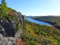
Looking east on the Overlook
towards the Grand Sable Dunes
< < < A relatively short, handicapped accessible trail leads to the Log Slide Overlook. Both this trail and the one to the falls are among the few in the park that allow dogs.
)
The beach below the Overlook.
)
Looking west towards the Au Sable Lighthouse.
Au Sable Lighthouse Hiking Trail. The Au Sable Lighthouse can be reached by a 3 mile round trip hike along a woods road from the Hurricane River campground.
)
The light keepers residence housed two families, the head keeper and the assistant.
Lighthouse Tours are offered during the summer months. Click Here to learn more about the tours and the Au Sable Light Station here.
More Hiking Trails - There are a few more day hiking and walking trails at the Grand Marais end of the park. Older maps indicate the road (County H58) is an unimproved sand road west of Hurricane River campground, but recently the road has been paved all the way to Munising. Some of these trails also allow pets - if on a 6 foot leash. For ambitious day hikers without pets and overnight backpackers, the Lakeshore-North Country runs the entire length of the park and provides some great hiking with spectacular vistas. Several trailhead spurs intersect with the Lakeshore trail allowing longer day trips.
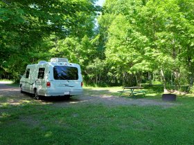
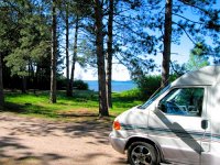
Camping and Campgrounds - 3 drive-in campgrounds exist within the park providing water, tables, grills and toilets. There are no showers nor electric hookups so RV campers will have to dry camp. Also know that the access is via unpaved sand roads. Just south of the park are several more campgrounds located in Lake Superior State Forest, but are also limited in terms of services like electricity and showers.
In addition there are 13 backcountry campsites sprinkled along the Lakeshore Trail and 7 group sites. These are very rustic - wilderness style camp sites: no potable water and only a few have toilets. Camping is allowed only at designated sites and pets are not allowed on backcountry trails or in backcountry campgrounds.
As of August 2019 all campgrounds in the park are now by online reservation ONLY-- this includes Hurricane River, Twelvemile Beach, and Little Beaver Lake. pictured rocks - recreation.gov
Pictured Rocks Links
![]() Get an Adobe PDF file from the National Park Service showing hiking trails and campgrounds.
Get an Adobe PDF file from the National Park Service showing hiking trails and campgrounds.
![]() Other Resources to Plan Your Visit to Pictured Rocks National Park.
Other Resources to Plan Your Visit to Pictured Rocks National Park.
![]() Pictured Rocks National Lakeshore Park - Western side: Munising Area - Miners Castle, Miners Falls, Visitor Center.
Pictured Rocks National Lakeshore Park - Western side: Munising Area - Miners Castle, Miners Falls, Visitor Center.
![]() See our Pictured Rocks Boat Cruise.
See our Pictured Rocks Boat Cruise.
More Links
Michigan Upper Peninsula
Lake Superior Circle Drive Attractions
![]() Munising, Michigan - Waterfalls, Camping, Attractions
Munising, Michigan - Waterfalls, Camping, Attractions
![]() Copper Harbor & Keweenaw Peninsula
Copper Harbor & Keweenaw Peninsula
![]() Ontario East Shore Lake Superior Scenic Drive
Ontario East Shore Lake Superior Scenic Drive
![]() Advantage Motel and Hotel-Resort Lodging in Michigan UP Circle Tour Cities
Advantage Motel and Hotel-Resort Lodging in Michigan UP Circle Tour Cities
SuperiorTrails.com - Reinhold Development - 2023

-
Upper Peninsula Michigan
- Michigan Upper Peninsula Travel
- Baraga, MI
- Black River Harbor Campground & Waterfalls
- Fall Color Black River Scenic Byway
- Copper Harbor, MI
- Grand Marais, MI
- Keweenaw Peninsula
- Keweenaw Peninsula Scenic Drive
- Keweenaw Fall Color
- Hancock-Houghton, MI
- Ironwood Michigan
- Marquette, MI
- Best Restaurants Marquette
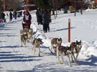
- UP 200 Sled Dog Race
- Marquette to Sault Ste Marie
- Munising, MI
- Munising Ski Snowshoe
- Pictured Rocks National Park
- Porcupine Mountains State Wilderness Park
- Sault Sainte Marie
- Tahquamenon Falls State Park
- The Soo Locks
- Upper Peninsula Camping
- Upper Peninsula Waterfalls
- Upper Peninsula Winter Events
- Travel Map Eastern Upper Peninsula
- Travel Map Western Upper Peninsula
- Fall Color Scenic Drives
- Winter Events Upper Peninsula
- Upper Peninsula Golf Courses
Winter - Michigan UP
Winter - Wisconsin Winter - Minnesota
Winter - Sault Ste Marie.
Best Upper Peninsula Campgrounds
Lake Superior Camping
& Campground Directory
Best Camping along Lake Superior.
 Tahquamenon Falls State Park and Waterfalls.

See the Pictured Rocks on a Pictured Rocks Boat Cruise
Michigan Upper Peninsula Waterfalls
![]()
Travel Information |
Motels & Hotel Directory |

Lake Superior Circle Tour Road Map & Guide to Travel Attractions around Lake Superior.
Identifying Lake Superior Agates and Beach Rocks.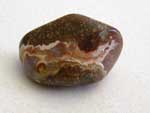
 Black River Harbor
Scenic Byway - Fall Color.
Best Rock Picking and Agate Hunting Beaches in the Upper Peninsula. 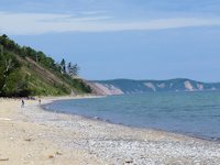
Tahquamenon Falls State Park and Waterfalls
 Porcupine Mountains State Park was voted #2 Best State Park in the U.S.


See our Reviews of Michigan Upper Peninsula Golf Courses around Lake Superior.