 |
 |
|
Potato River Water Falls in Fall Color
Gurney, Wisconsin

Some great Wisconsin Fall Color from the top of Potato Falls - near Gurney, Wisconsin
You can get some great fall color pictures taking a little detour off the Lake Superior Circle route by taking a drive to Potato River Falls and then continuing on to Copper Falls State Park. Take the turn-off about 12 miles west of Hurley, Wisconsin along US Highway 2, south on to Wisconsin 169 through the community of Gurney, WI. ) At the southern edge of town, look for the town road to Potato River County Park. (Or if you are coming first from Copper Falls State Park, go Northwest on highway 169 about 13 miles to the turn-off to Potato River County Park.)
At the southern edge of town, look for the town road to Potato River County Park. (Or if you are coming first from Copper Falls State Park, go Northwest on highway 169 about 13 miles to the turn-off to Potato River County Park.)
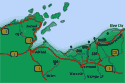 Fall Color Tour Map
)
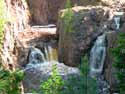
) Potato River Park & Waterfalls
Potato River Park & Waterfalls
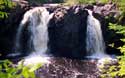
Fall color was near its peak. We found a nice parking place in front of the picnic shelter and near the trail to the upper falls (shown far right). > > >
)
)
The Upper Falls begins in a series of stair step cascades and then drops over two higher falls. > > >
)
)
Then the river reassembles (near right) before dropping over the lower falls (far right). > > >
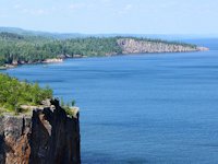
 Copper Falls State Park & Waterfalls
If you want to go to Copper Falls, return to Hwy 169 and proceed southwest. You'l reach the entrance to Copper Falls State Park in about 13 miles. After visiting Copper Falls you can return to US Highway 2 by driving north along Highway 13 to Ashland, Wisconsin.
Scenic Fall Color Drives - nearby Upper Peninsula, Michigan
) If you are heading east towards Ironwood and the UP and just made a slight detour to view Potato Falls, you can find some excellent camping, terrific waterfalls, and great fall color scenery just over the border in Michigan's Upper Peninsula.
If you are heading east towards Ironwood and the UP and just made a slight detour to view Potato Falls, you can find some excellent camping, terrific waterfalls, and great fall color scenery just over the border in Michigan's Upper Peninsula.
Return to US Highway 2, go east till Wisconsin 122, turn north towards the Lake. Shortly after the turnoff to Saxon Harbor you'll join up with Michigan 505 that goes by the Little Girls Point Camping and Picnic area. From there you can continue on to the Black River Harbor Recreation Area and subsequently the Presque Isle Recreation Area and if you want even more fall scenic color beauty - the Porcupine Mountains. (see our color tour travel map above)
Copper Falls State Park
is near Mellen, Wisconsin.

Upper Amnicon Falls at Amnicon Falls State Park.
![]() Go Here for More Superior Scenic Fall Color Tour Ideas.
Go Here for More Superior Scenic Fall Color Tour Ideas.
![]() Porcupine Mountains Park - Waterfalls, Presque Isle River & Lake of the Clouds Scenic Area.
Porcupine Mountains Park - Waterfalls, Presque Isle River & Lake of the Clouds Scenic Area.
![]() Camping and Campgrounds Bayfield WI and Bayfield Peninsula.
Camping and Campgrounds Bayfield WI and Bayfield Peninsula.
SuperiorTrails.com - Reinhold Development - 2023

- Lake Superior Circle Tour
- Wisconsin Travel
- Wisconsin Travel Guide
- Bayfield WI
- Big Top Chautauqua
- Cornucopia WI
- Apostle Islands
- Madeline Island
- Big Bay State Park
- Amnicon Falls Park
- Ashland, WI
- Copper Falls State Park
- Fall Color Scenic Drives
- Lake Superior Ice Caves
- Superior, WI
- Superior Burgers & Pizza
- Best Superior Wi Pubs
- Superior Wi Dragonboat Race
- Washburn, WI
- Wisconsin Golf
- Wisconsin Travel Map
- Wisconsin Water Falls
- Wisconsin Winter Events
- Wisconsin Fall Color
- Minnesota North Shore
- Ontario Travel
- Michigan Upper Peninsula
- Travel Resources
- Agates & Beach Rocks
- About Us

Bayfield Holiday Events & Activities
Duluth Holiday Events and Fun.
Winter - Michigan UP
Winter - Wisconsin Winter - Minnesota
Winter - Sault Ste Marie.
 See our guide to interesting and fun things to see and do on Madeline Island.
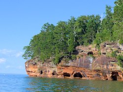
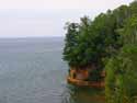
See photos from our recent Apostle Islands
Sea Caves cruise.
Apostle Islands Sea Caves Hiking Trail is about a 3.5 mile round trip from Meyers Beach to the Bayfield Sea Caves
Lake Superior Travel Directories
Minnesota Travel
Wisconsin Travel
Upper Peninsula
Ontario Travel
Orchard Touring
Take a scenic drive of
farms and orchards in the Bayfield area.
![]()

Hotel, Motel Lodging
Ashland, Superior, Ironwood, Wisconsin South Shore
![]()

Lake Superior Circle Tour Road Map & Guide to Travel Attractions around Lake Superior.

Duluth's amazing Bentleyville Duluth Christmas Lights Village.
How to recognize Lake Superior Agates and Beach Rocks.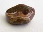
Best Wisconsin Lake Superior Agate Beaches
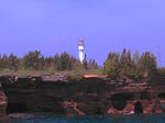
See the lighthouses on an Apostle Islands Cruise.
Copper Falls State Park
is near Mellen, Wisconsin.
Enjoying the great swimming Beach Big Bay State Park on Madeline Island.

See our
Reviews of Best Wisconsin golf courses on Lake Superior.

)