 |
 |
|
Baraga to Marquette Michigan - Waterfalls, Hiking & Camping - South Shore Lake Superior Circle Tour

From Baraga to Marquette, on US Highway 41, you travel away from the lake. Canyon Falls on the Sturgeon River is a few miles south of the town of Alberta. Look for the rest stop west of the highway. Shortly after the falls, Highway 41 intersects with Michigan 28, and then turns east towards Marquette.
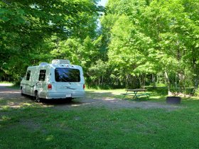
Along this stretch, you pass Craig Lake State Park - a nice little quartet of canoeing-only lakes with a 2 rustic back-country cabins for rent - and Lake Michigamme, a large reservoir lake with a reputation for good walleye fishing. The village of Michigamme, on the west end of the lake, has some charm and history to it - worth a stop. Van Riper State Park is on the east end of Michigamme and is a full service family oriented campground. There are a few miles of hiking trails; those along the river are the most scenic. In the summer of 2004, due to dallying too long in the Marquette area, we made an unscheduled overnight stay at a private campground on the north shore of the lake - Michigamme Shores. We found their accomodations and camp layout up to snuff!
~~~"Click" on smaller images for a larger picture~~~
Baraga, L'Anse Michigan
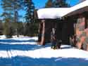
We stayed at Baraga State Park, which is adjacent to US Highway 41 south of town. The park overlooks the lake and is an ideal campsite for the traveler who is just passing through the area or to use as a base camp for exploring attractions in Baraga County.The state park is on a flat plane and open landscape with little natural screening between sites. It only has one modest hiking trail and a small playground and a picnic area by the lake. It does have showers and electric sites and a dump station for RV campers. The price was quite fair.
Waterfalls
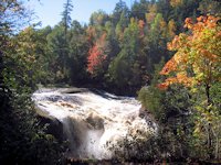
Baraga County is largely occupied by Copper Country State Forest and includes a number of mountains, streams, lakes and water falls providing lots of hiking and backcountry exploring opportunities. Some rainy weather prevented us from taking in as many waterfall hikes as we would have liked, but we did get to see 3 of them.
)
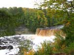
< < < Canyon Falls is a 10-15 minute hike from the Canyon Falls wayside picnic area off US Highway 41 about 10 miles south of Baraga.
)
The rapids below the falls and the canyon itself are also impressive.
)
One map shows another falls downstream from here, but I didn't notice a trail to it.
)
< < < Silver River Falls is off Skanee Road, east of the community of Zeba.
)
)
Slate River Falls is a few miles further up the road and off Arvon Road. As this was July 3, the water flow was a fraction of what it is in the spring - when where Jo and Hans are sitting would be covered with water! (Nearby Mount Arvon is Michigan's highest elevation. )
~ ~ ~ ~ ~ ~
There are several other falls in the area we look forward to finding and exploring in the future. Among them are Sturgeon Falls, Tibbets Falls and the falls and hiking around Big Eric's Bridge.
Camping
In addition to Baraga State park, L'Anse township has a 30 unit campground across the bay from Baraga. East and north of L'Anse, at the end of Skanee Road, is a rustic state forest campground at Big Eric's Bridge and Falls. A privately operated campground, Witz Marina and campground, is also on Skanee Road. On the other side of the bay, north of Baraga along US 41 is another private campground - Ojibwa Campground, with 50 units.
![]() Visitor Information & Attractions - Baraga County Tourism Association
Visitor Information & Attractions - Baraga County Tourism Association
Traveling East towards Marquette
)
Leaving Baraga, US Highway 41 takes you south and by Canyon Falls (pictured previously above). After the turnoff to Covington the highway turns east. About 8 miles there is supposed to be a wayside with a hiking trail to Tioga Falls. We keep missing this one! The next point of interest is the village of Michigamme.
Jo found this interesting Quilt Shop . . . so I suppose a stop in Michigamme will be on our future itinerary! > > >
* Go here for a listing of more Quilt Shops around Lake Superior.
Camping between Baraga and Marquette
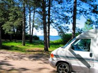
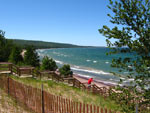
A few miles before Michigamme Village, there's a state forest compground on Beaufort Lake. On the northern end of Lake Michigamme is a private campground we found satisfactory and reasonably priced: Michigamme Shores. On the eastern end is Van Riper State Park - popular with families and fisherman. There's not much for camping between Van Riper and Marquette - nor in Marquette itself.
However, lots of good hotel-motel choices - beginning at Ishpeming and continuing to Marquette. For traveling campers, this is a good opportunity to enjoy the comforts and conveniences of a motel stay.

Ishpeming, Michigan
As you approach Marquette on US 41 you'll go through Ishpeming and Nauganee. Two attractions here are of note. The famous Da Yoopers Tourist Trap and The Iron Industry History Museum.
Traveling North Towards Keweenaw Peninsula
US Highway 41 north of Baraga runs adjacent to the lake with some nice views. As it gets closer to Houghton, it runs along Portage Lake-Portage River which bisects the Keweenaw Peninsula - essentially making it an island. In the past we've been too anxious to get to Copper Harbor and zipped through Houghton-Hancock, but since we've had time to enjoy the area. History buffs will enjoy spending some time in the area. As far as camping in the area, we have stayed at the Lake Linden Township park (north of Hancock on Highway 26). Reasonable price, spacious site. We've also stayed FJ McLain State Park - west of Hancock and the city of Houghton RV Park. Both are excellent choices.
Traveling West Towards Ontonagon
If you elect to bypass the Keweenaw, you take Michigan 38 from Baraga. Good road, forest landscape, not much of interest along the route, nor much for camping. At the intersection with Michigan 26, you can go south to the village of Rockland and then take a side trip to Historic Victoria, before continuing on to Ontonagon. But if you are in a hurry, just stay on Highway 38 till Ontonagon. Then head west along Lake Superior to Silver City and the Porcupine Mountains.
![]() See the Porcupine Mountains, one of the upper midwest's best hiking and wilderness camping destinations.
See the Porcupine Mountains, one of the upper midwest's best hiking and wilderness camping destinations.
Michigan South Shore Western UP Waterfalls: |
Links
![]() Scenic Drive Marquette Michigan to Sault Ste. Marie
Scenic Drive Marquette Michigan to Sault Ste. Marie
![]() Pictured Rocks National Lakeshore Park
Pictured Rocks National Lakeshore Park
![]() Presque Isle River Waterfalls & Porcupine Mountains
Presque Isle River Waterfalls & Porcupine Mountains
![]() Advantage Motel and Hotel-Resort Lodging in Michigan UP Circle Tour Cities
Advantage Motel and Hotel-Resort Lodging in Michigan UP Circle Tour Cities
SuperiorTrails.com - Reinhold Development - 2023

-
Upper Peninsula Michigan
- Michigan Upper Peninsula Travel
- Baraga, MI
- Black River Harbor Campground & Waterfalls
- Fall Color Black River Scenic Byway
- Copper Harbor, MI
- Grand Marais, MI
- Keweenaw Peninsula
- Keweenaw Peninsula Scenic Drive
- Keweenaw Fall Color
- Hancock-Houghton, MI
- Ironwood Michigan
- Marquette, MI
- Best Restaurants Marquette
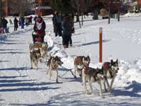
- UP 200 Sled Dog Race
- Marquette to Sault Ste Marie
- Munising, MI
- Munising Ski Snowshoe
- Pictured Rocks National Park
- Porcupine Mountains State Wilderness Park
- Sault Sainte Marie
- Tahquamenon Falls State Park
- The Soo Locks
- Upper Peninsula Camping
- Upper Peninsula Waterfalls
- Upper Peninsula Winter Events
- Travel Map Eastern Upper Peninsula
- Travel Map Western Upper Peninsula
- Fall Color Scenic Drives
- Winter Events Upper Peninsula
- Upper Peninsula Golf Courses
Winter - Michigan UP
Winter - Wisconsin Winter - Minnesota
Winter - Sault Ste Marie.
Best Upper Peninsula Campgrounds
Lake Superior Camping
& Campground Directory
Best Camping along Lake Superior.
 Tahquamenon Falls State Park and Waterfalls.

Marquette Michigan, the UP's largest city.

Houghton Michigan's unique aerial lift bridge.
Michigan Upper Peninsula Waterfalls
![]()
Travel Information |
Motels & Hotel Directory |

Lake Superior Circle Tour Road Map & Guide to Travel Attractions around Lake Superior.
Identifying Lake Superior Agates and Beach Rocks.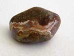
 Black River Harbor
Scenic Byway - Fall Color.
Best Rock Picking and Agate Hunting Beaches in the Upper Peninsula. 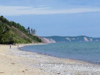
Copper Harbor & Keweenaw Scenic Drive
 Porcupine Mountains State Park was voted #2 Best State Park in the U.S.


See our Reviews of Michigan Upper Peninsula Golf Courses around Lake Superior.