 |
 |
|
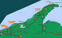
Porcupine Mountain State Park,
Upper Peninsula Michigan
Hiking, Waterfalls, Camping, Scenic Overlooks along the South Shore of the Lake Superior Circle Tour
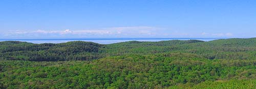
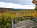
View from Summit Peak, Porcupine Mountain State Park

- Camping Campground Information in the Porkies
- Hiking and Back-Packing Trails
- Hiking Trail Map & Facility Info
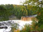
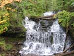
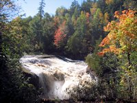
- Waterfalls Presque Isle River
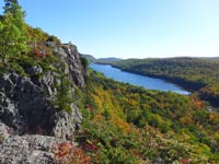
- Lake of the Clouds Scenic Overlook
- More Scenic Photos of the Porkies
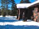
- Winter in the Porkies

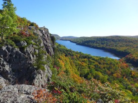
A breathtaking view from the
Lake of the Clouds Scenic Overlook
Voted by Readers of USA Today-10Best as the 2nd best State Park in the United States, the "Porkies" offers superb scenic views, top-notch hiking and backpacking, mountain biking, and other pursuits in a 60,000 acre wilderness preserve. To get to Porcupine Mountains State Park from the west, we recommend traveling via US 2 to Wakefield, Michigan, then take Michigan 28 and Michigan 519 to the Presque Isle Unit of the porkies. For the casual visitor, There's camping, a picnic area and a nice day hiking trail network around its fantastic waterfalls. And of course, for the serious backpacker, Presque Isle connects with the extensive backpacking trails that run through the porkies.
Getting to the Porkies
If you are coming from the east, we recommend going through Ontonagon via Highway 64 to Silver City. Visitor attractions at the east end are the Wilderness Visitor Center, picnic areas along the lake, Union Bay campground, and Lake of the Clouds scenic lookout. If you are coming from the west, take Michigan 519 out of wakefield. The Presque Isle Camping unit is at this end of the park plus their most magnificient waterfalls. After leaving the Preque Isle unit, you take the south boundary road which runs between the west and east ends. Several trailheads for short or multi-day hikes are along this road. But the most "don't miss" attraction is the road and a trail to Summit Peak (pictured below).
)
The Porkies cover 60,000 acres and is Michigan's largest state park. Within the park is a block of old-growth forest comprising almost 35,000 acres and considered by some to be the biggest and best stand of virgin Northern Hardwoods and Hemlock in North America.
In the picture to the right, Jo and Hans stand by a huge old-growth Yellow Birch tree that is representative of what is in abundance in the Porkies.
)
)
Summit Peak Hiking Trail
The half mile hike to Summit Peak is reached from the trail head off the South Boundary Road. At 1958 feet elevation, it offers quite a panoramic view of the area.
)
)
A boardwalk covers the last few hundred yards of the Summit Peak trail.
Far Right. Jo and Hans take a rest at the bottom of the Observation Tower.
) There is also an observation deck before you get to the tower which offers some great views for those not willing to climb the steps to the top of the tower.
There is also an observation deck before you get to the tower which offers some great views for those not willing to climb the steps to the top of the tower.
![]() Fall Color Pictures from the top of Summit Peak.
Fall Color Pictures from the top of Summit Peak.
)
Several of the Park's hiking trails intersect with Summit Peak. See Map of Summit Peak Hiking Trails > > >


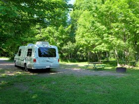
The Porkies offer a wide variety of camping experiences from isolated backcountry backpacking campsites along the hiking trails, to backcountry cabins, a semi-modern campground, and a full service modern campground with electricity and showers.
)
)
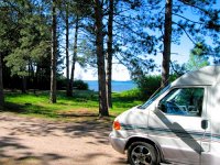
As you approach the Porkies from Silver City, there are several picnic waysides along this sand beach. (near right)
But at Union Bay Campground further west, the beach topography changes dramatically to Copper Harbor Sandstone. (far right)
- Get More Information on Camping in Porcupine Mountains State Park

![]() Porcupine Mountains - Summit Peak, Union Bay Campground (this page)
Porcupine Mountains - Summit Peak, Union Bay Campground (this page)
![]() Camping and Campgrounds - Porcupine Mountains State Park
Camping and Campgrounds - Porcupine Mountains State Park
![]() Hiking and Back-Packing in Porcupine Mountains Wilderness Park
Hiking and Back-Packing in Porcupine Mountains Wilderness Park
![]() Lake of the Clouds Scenic Overlook
Lake of the Clouds Scenic Overlook
![]() Porcupine Mountains - See the colorful Fall Foliage
Porcupine Mountains - See the colorful Fall Foliage
![]() Waterfalls, Presque Isle River & Campground
Waterfalls, Presque Isle River & Campground
![]() More Scenic Porcupine Mountains Pictures
More Scenic Porcupine Mountains Pictures
![]() Porcupine Mountains - Winter Attractions
Porcupine Mountains - Winter Attractions
![]() Hiking Trail Map & Facility Info on the Porkies
Hiking Trail Map & Facility Info on the Porkies
More Porcupine Mountains State Park Resources
Michigan DNR Porcupine Mountain State Park Website
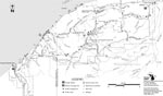
![]() Here's a full map you can print out showing the campsites, back-country rustic cabins, hiking trails, waterfalls, and other points of interest within Porcupine Mountains Wilderness State Park.
Here's a full map you can print out showing the campsites, back-country rustic cabins, hiking trails, waterfalls, and other points of interest within Porcupine Mountains Wilderness State Park.
![]() Here's a link to a publication with more info on visiting the Porcupine Mountains - Porcupine Mountains Visitor.
Here's a link to a publication with more info on visiting the Porcupine Mountains - Porcupine Mountains Visitor.
More Links
Michigan Upper Peninsula
Lake Superior Circle Drive Attractions
![]() Going east towards Marquette, Munising and Pictured Rocks . . . More waterfalls, hiking pages, and scenic attractions from Munising through Tahquemenon Falls to Sault Ste. Marie.
Going east towards Marquette, Munising and Pictured Rocks . . . More waterfalls, hiking pages, and scenic attractions from Munising through Tahquemenon Falls to Sault Ste. Marie.
![]() Going west towards Black River Scenic Area . . . waterfalls, hiking, camping, rock picking.
Going west towards Black River Scenic Area . . . waterfalls, hiking, camping, rock picking.
![]() Copper Harbor & Keweenaw Peninsula
Copper Harbor & Keweenaw Peninsula
![]() Directory Upper Peninsula Travel Pages . . . on SuperiorTrails
Directory Upper Peninsula Travel Pages . . . on SuperiorTrails
SuperiorTrails.com - Reinhold Development - 2023

-
Upper Peninsula Michigan
- Michigan Upper Peninsula Travel
- Baraga, MI
- Black River Harbor Campground & Waterfalls
- Fall Color Black River Scenic Byway
- Copper Harbor, MI
- Grand Marais, MI
- Keweenaw Peninsula
- Keweenaw Peninsula Scenic Drive
- Keweenaw Fall Color
- Hancock-Houghton, MI
- Ironwood Michigan
- Marquette, MI
- Best Restaurants Marquette
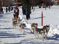
- UP 200 Sled Dog Race
- Marquette to Sault Ste Marie
- Munising, MI
- Munising Ski Snowshoe
- Pictured Rocks National Park
- Porcupine Mountains State Wilderness Park
- Sault Sainte Marie
- Tahquamenon Falls State Park
- The Soo Locks
- Upper Peninsula Camping
- Upper Peninsula Waterfalls
- Upper Peninsula Winter Events
- Travel Map Eastern Upper Peninsula
- Travel Map Western Upper Peninsula
- Fall Color Scenic Drives
- Winter Events Upper Peninsula
- Upper Peninsula Golf Courses
Winter - Michigan UP
Winter - Wisconsin Winter - Minnesota
Winter - Sault Ste Marie.
Best Upper Peninsula Campgrounds
Lake Superior Camping
& Campground Directory
Best Camping along Lake Superior.
 Tahquamenon Falls State Park and Waterfalls.
Fall Color at Porcupine Mountains State Park
Upper Peninsula Fall Color
Tour Map
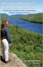
Porcupine Mountains Guide for Hikers, Backpackers, Campers and Winter Visitors
The third edition of the most comprehensive guide to the hiking trails and backcountry camping of Porcupine Mountains State Park. Great for planning your trip or tuck the book in your backpack during your hike.
Go here for Upper Peninsula camping, hiking, and backpacking guides
Michigan Upper Peninsula Waterfalls
![]()
Travel Information |
Motels & Hotel Directory |

Lake Superior Circle Tour Road Map & Guide to Travel Attractions around Lake Superior.
Identifying Lake Superior Agates and Beach Rocks.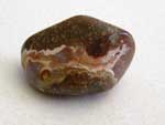
 Black River Harbor
Scenic Byway - Fall Color.
Best Rock Picking and Agate Hunting Beaches in the Upper Peninsula. 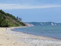
 Hiking Michigan's Upper Peninsula
See Eric Hansen's guide to hiking the Upper Peninsula and other guides for best hiking in the Upper Peninsula [More info]
 Porcupine Mountains State Park was voted #2 Best State Park in the U.S.


See our Reviews of Michigan Upper Peninsula Golf Courses around Lake Superior.