 |
 |
|
Page 1 - Keweenaw Peninsula Scenic Drive Page 2 - Keweenaw Scenic Drive Keweenaw Fall Foliage Scenic Drives
|

Copper Harbor Michigan & the Keweenaw Peninsula - Hiking, Camping, Travel Attractions. South Shore Lake Superior Circle Tour
Heading to the Keweenaw & Copper Harbor from the Porcupine Mountains, take Highway 64 east to Ontonagon. If you are in a hurry, take Highway 38 to Highway 26 which goes north to Houghton-Hancock.
BTW. An interesting side excursion is taking US highway 45 to Rockland, then take a county road SW (4 miles) to the historic community of Victoria. Old Victoria Restoration Site is a restored pioneer mining homestead that is an interesting tour. Nearby there is a waterfall at the Lake Victoria Dam (actually a powerplant spillway). The drive takes you down into the steep canyon formed by the Ontonagon River and then up again to the pioneer village. Figure about an hour plus for the drive and tour.
Continuing on Highway 26 you eventually arrive in historic Houghton-Hancock, Michigan - home of Michigan Tech University, the Seaman Mineral Museum, and gateway to the Keweenaw National Historical Park and the Keweenaw Peninsula.
Houghton-Hancock Gateway to the Keweenaw
)
Usually we're so looking forward to getting to Copper Harbor that, except for getting gas and ice, we whiz right through these twin cities. To the right is a view of Hancock across the Portage Waterway from Houghton. These are old towns and have some history worth appreciating if your interest lies in this direction. In recent years we've spent more time in this area to catalog interesting places to see and things to do.
![]() Go Here for info on Houghton, Michigan Travel Attractions and recreation in the Houghton-Hancock area.
Go Here for info on Houghton, Michigan Travel Attractions and recreation in the Houghton-Hancock area.
Crossing the bridge into Hancock, you continue through the mining communities of Calumet and Larium, staying on Highway 26 & 41, until the town of Phoenix. Here you can take the lake shore scenic route (Hwy 26) through Eagle River & Eagle Harbor or the more direct route (Hwy 41) which is also scenic (especially during fall color) but does not go along the lakeshore.
The route we profile below is the Lake Shore Drive route, starting at Eagle River.
Eagle River, MI Keweenaw Peninsula
Eagle River has a nice long public sand beach set up with picnic tables and fire rings. The last time we were there, we watched a wind surfer riding the waves in, with some spectacular leaps, and then tacking back out to do it all over again. Quite an athletic performance.
)
)
)
One of the outstanding attractions of Eagle River is Fitzgerald's Restaurant in the Eagle River Inn. They have a great menu ranging from quick sandwiches to gourmet cuisine, all prepared and served with TLC. And reasonable prices, too. Helping make this a favorite stop is an extensive craft beer menu. Top this off with a great view of Lake Superior and a comfortable ambience, and you can see why it is one of the top lakeside dining places around Superior.
![]()
)
)
The Jam Pot
Between Eagle River and Eagle Harbor on Highway 26 near Jacobs Falls is a necessary stop for anyone taking the scenic Keweenaw Peninsula Drive. Tthe Monks of the Holy Transfiguration Skete operate a bakery and jams/jellies preserves store - Monday - Saturday (closed Sundays) whose treats are second to none . . . and consuming them can't be a sin because they were made by Catholic Monks!
![]()
)
)
)
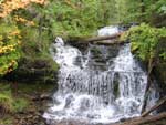
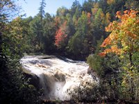
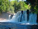
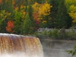
Jacobs Falls is a little guy, compared to what we seen elsewhere around Lake Superior but still enchanting. There's a few more waterfalls along the way, but in general the Keweenau waterfalls are long on cute . . . but short on impressive . . . which is why I have included few of them in our travel pages.
Eagle Harbor, Michigan
)
Big Sand Bay, just west of the village of Eagle Harbor, has an extensive public sand beach, great for swimming and for rock picking. There's a large parking area with bathrooms, picnic tables, and volleyball area on the beach.
)
Eagle Harbor's protected swimming beach is just about 100% sand (no rock picking) and should be warm enough for swimming or sunbathing throughout the summer.
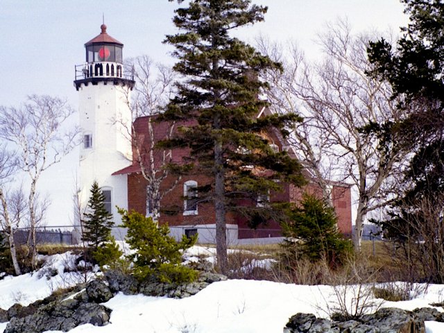
) Looking across the bay to Eagle Harbor's sand beach. At the extreme right of the photo, just out of view, is a point on which Eagle Harbor's Lighthouse sits. Still in use, the light itself is now automated. But the building has been restored and furnished in an historically accurate fashion by the Keweenaw Historical Society and is now open for tours from June to October.
Looking across the bay to Eagle Harbor's sand beach. At the extreme right of the photo, just out of view, is a point on which Eagle Harbor's Lighthouse sits. Still in use, the light itself is now automated. But the building has been restored and furnished in an historically accurate fashion by the Keweenaw Historical Society and is now open for tours from June to October.
) All along the Keweenaw Scenic Lakeshore drive are little parks and pull-offs for picknicing and walking along the lakeshore like this one between Eagle Harbor and Copper Harbor.
All along the Keweenaw Scenic Lakeshore drive are little parks and pull-offs for picknicing and walking along the lakeshore like this one between Eagle Harbor and Copper Harbor.
Brockaway Mountain, Copper Harbor, and the Eastern side of the Keweenaw Peninsula - - - continued on the next page
Michigan Upper Peninsula Lake Superior Circle Drive
![]() Going east through Baraga to Marquette
Going east through Baraga to Marquette
![]() Traveling West Towards Ontonagon & Porcupine Mountains State Park
Traveling West Towards Ontonagon & Porcupine Mountains State Park
SuperiorTrails.com - Reinhold Development - 2023

-
Upper Peninsula Michigan
- Michigan Upper Peninsula Travel
- Baraga, MI
- Black River Harbor Campground & Waterfalls
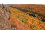
- Fall Color Black River Scenic Byway
- Copper Harbor, MI
- Grand Marais, MI
- Keweenaw Peninsula
- Keweenaw Peninsula Scenic Drive
- Keweenaw Fall Color
- Hancock-Houghton, MI
- Ironwood Michigan
- Marquette, MI
- Best Restaurants Marquette
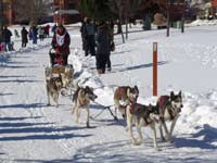
- UP 200 Sled Dog Race
- Marquette to Sault Ste Marie
- Munising, MI
- Munising Ski Snowshoe
- Pictured Rocks National Park
- Porcupine Mountains State Wilderness Park
- Sault Sainte Marie
- Tahquamenon Falls State Park
- The Soo Locks
- Upper Peninsula Camping
- Upper Peninsula Waterfalls
- Upper Peninsula Winter Events
- Travel Map Eastern Upper Peninsula
- Travel Map Western Upper Peninsula
- Fall Color Scenic Drives
- Winter Events Upper Peninsula
- Upper Peninsula Golf Courses
Winter - Michigan UP
Winter - Wisconsin Winter - Minnesota
Winter - Sault Ste Marie.
Best Upper Peninsula Campgrounds
Lake Superior Camping
& Campground Directory
Best Camping along Lake Superior.
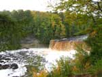 Tahquamenon Falls State Park and Waterfalls.

Marquette Michigan, the UP's largest city.
Copper Harbor and Brockaway Mountain
Michigan Upper Peninsula Waterfalls
![]()
Travel Information |
Motels & Hotel Directory |

Lake Superior Circle Tour Road Map & Guide to Travel Attractions around Lake Superior.
Identifying Lake Superior Agates and Beach Rocks.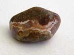
 Black River Harbor
Scenic Byway - Fall Color.
Best Rock Picking and Agate Hunting Beaches in the Upper Peninsula. 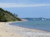
 Porcupine Mountains State Park was voted #2 Best State Park in the U.S.


See our Reviews of Michigan Upper Peninsula Golf Courses around Lake Superior.