 |
 |
|
Best Campgrounds: Reviews of Ontario Provincial Parks and Campgrounds along the Lake Superior Circle Route

Campground - Pancake Bay Provincial Park
Our Reviews of Favorite Camping and Campgrounds Ontario Eastern North Shore of Lake Superior
Several nice Provincial Parks and private campgrounds are convenient to Superior Circle Route travelers along the route from Sault Ste. Marie to Marathon, Ontario. We've included here those parks and camping areas we've found suitable as overnight stops for the circle tour traveler. Some of these featured parks and campgrounds have additional attractions that make them worth spending a few additional hours or even an extra day or three to better sample what they have to offer.
![]() Camping & Parks Reviews -
Camping & Parks Reviews -
Western Section Ontario Lake Superior Circle Tour
Neys Provincial Park
Neys is a few miles west of Marathon off Highway 17 on Ashburton Bay of Lake Superior and bordered on the west end by the Little Pic River. There are four camping areas within the park with a total of 144 sites; 29 sites have electric hookups. Each camping area is serviced by toilets and water hydrants, plus there is a centrally located shower and laundry facility. Beach combing and hiking are the main recreational activities.
Pukaskwa National Park
) Pukaskwa is a protected wilderness area most known for whitewater and wilderness canoeing, sea kayaking, and wilderness backpacking. But the Hattie Cove campground near Marathon opens up a portion of the park to less challenging endeavors. The protected Hattie Cove offers swimming, kayaking, fishing, canoeing and sailing. Paddlers can also enjoy Halfway Lake. Other attractions are scenic hikes, and nature trails. The campground offers a nature center, flush toilets and showers, and handicapped accessible facilities. There are 67 sites, 29 with electricity.
Pukaskwa is a protected wilderness area most known for whitewater and wilderness canoeing, sea kayaking, and wilderness backpacking. But the Hattie Cove campground near Marathon opens up a portion of the park to less challenging endeavors. The protected Hattie Cove offers swimming, kayaking, fishing, canoeing and sailing. Paddlers can also enjoy Halfway Lake. Other attractions are scenic hikes, and nature trails. The campground offers a nature center, flush toilets and showers, and handicapped accessible facilities. There are 67 sites, 29 with electricity.
![]() Go here for more info on Pukaskwa
Go here for more info on Pukaskwa
![]() Go here for Hattie Cove campground map
Go here for Hattie Cove campground map
Obatanga and White Lake Provincial Parks
These two parks are located in the relatively isolated 108 mile stretch of road between Marathon & Wawa Ontario. This portion of the Lake Superior route is substantially inland from the lake with a more flat and barren topography. Because this stretch lacks the scenic attractions found on the rest of the Ontario route, we've never stayed at either of these parks.
Fishing is an important attraction at both of these parks and White Lake is popular with wilderness canoe and kayak trippers who are paddling and wilderness camping on the White River.
For the traveler for whom a stop along this route fits the plan either of these parks would be satisfactory.
![]() Go here for the Obatanga Park website
Go here for the Obatanga Park website
![]() Go here for the White Lake Park website
Go here for the White Lake Park website
Lake Superior Provincial Park
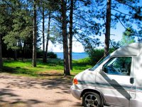
) 13 km south of Wawa, Ontario Lake Superior PP is a very large park offering high quality hiking trails, backcountry backpacking, kayaking, canoeing, interior wilderness lakes, rivers, scenic vistas and an extensive Lake Superior shoreline and sandy beaches. The Visitor Centre and the Agawa Rock Pictographs are "must see" stops for the traveler who is just passing through. There are three day use picnic areas, two on Lake Superior and one on the Sand River. There are three campgrounds. The largest, Agawa Bay, is similar in layout to Pancake Bay Provincial Park (pictured at the top of this page) but with half as many camp sites. Rabbit Blanket campground also offers electric hookups and showers. Crescent Lake Campground is semi-modern.
13 km south of Wawa, Ontario Lake Superior PP is a very large park offering high quality hiking trails, backcountry backpacking, kayaking, canoeing, interior wilderness lakes, rivers, scenic vistas and an extensive Lake Superior shoreline and sandy beaches. The Visitor Centre and the Agawa Rock Pictographs are "must see" stops for the traveler who is just passing through. There are three day use picnic areas, two on Lake Superior and one on the Sand River. There are three campgrounds. The largest, Agawa Bay, is similar in layout to Pancake Bay Provincial Park (pictured at the top of this page) but with half as many camp sites. Rabbit Blanket campground also offers electric hookups and showers. Crescent Lake Campground is semi-modern.
Pancake Bay Provincial Park
)
Pancake Bay is a large Provincial Park located on a south facing protected bay of Lake Superior. The wide 3.2 km long sand beach is crisp, clean, and rarely crowded. It offers
ample space for sunbathing, beach combing, and in later summer - swimming. The park offers 325 nicely spaced, partially wooded campsites - of which 160 have electric service. A modern facility, it has showers, flush toilets, a park store, playground, dump stations, and a naturalist programme.
Camping Sault Ste. Marie, Ontario
The Lions Club Pointe Des Chenes Campground is located about 10 km west of Sault Ste. off Highway 550. It is a gated, family-oriented, facility with showers, electric hookups, dump station, convenience store, playground, 100 campsites and an expansive sand beach on Lake Superior's Whitefish Bay. The camp sites are partially wooded and on the small side. Even though tightly packed, there seems to be a community feel to the place that we enjoyed. At one time their prices were quite reasonable, but during our last visit (in 2014) the fee was only a few dollars less than the Provincial Parks.
There are two privately operated campgrounds on the north edge of the city and one on the eastern edge. In 2010 we tried the KOA campground north of town during our fall color tour and found it very satisfactory. Since Pointe Des Chenes raised their prices and it is about 12 km off the main circle tour route and with gas prices in Canada being higher than the US, in our opinion the KOA campground is a better value.
Links & Information

![]() Camping & Parks Reviews - Western Section Ontario Lake Superior Circle Tour
Camping & Parks Reviews - Western Section Ontario Lake Superior Circle Tour
![]() Master Lake Superior Circle Tour Campground Directory
Master Lake Superior Circle Tour Campground Directory
![]() "Advantage Rate" Hotel Motel Reservations - Ontario Circle Tour
"Advantage Rate" Hotel Motel Reservations - Ontario Circle Tour
![]() Canoeing, Camping & Fly In trips - Wabakimi Wilderness Park
Canoeing, Camping & Fly In trips - Wabakimi Wilderness Park
SuperiorTrails.com - Reinhold Development - 2023
Privacy Policy

- Lake Superior Circle Tour
- Minnesota North Shore
- Wisconsin Travel
- Upper Peninsula Michigan
- Michigan Upper Peninsula Travel Directory
- Camping in Upper Peninsula
- Keweenaw Peninsula Scenic Drives
- Copper Harbor - Keweenaw
- Black River Harbor Scenic Area
- Porcupine Mountains
- Pictured Rocks National Park
- Fall Color Porcupine Mountains
- Pictured Rocks National Park
- Tahquamenon Falls State Park
- Winter Events Upper Peninsula
- Ontario Travel
- Travel Resources
- Lake Superior Travel Planner
- Guide to Superior Travel Maps
- Lake Superior Travel Blog
- Lake Superior Golf Course Directory
- Lake Superior Campground Directory
- Finding Lake Superior Agates
- Fall Color Drives
- Fall Color Reports
- Scenic Byways Blog
- SEARCH this site
- Superior Travel Bookstore
- Snow & Weather Reports
- Agates & Beach Rocks
- About Us
Lake Superior Travel Directories
Minnesota Travel
Wisconsin Travel
Upper Peninsula
Ontario Travel
Lake Superior Camping
& Campground Directory
Best Camping along Lake Superior.
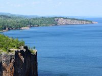
 Dramatic Roadside Scenery Rossport to Terrace Bay

Lake Superior Camping
& Campground Directory
Camping along the Lake Superior Circle Drive.
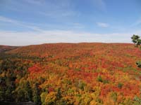
North Shore Fall Colors from the top of Moose Mountain.

Get *free* North of Superior
Travel guides
![]()
Hotel, Motel Lodging
Thunder Bay, Sault Ste. Marie, Ontario North Shore
![]()

Lake Superior Circle Tour Road Map & Guide to Travel Attractions around Lake Superior.

Best Scenic Fall Color Drives around Lake Superior

Ontario Lake Superior Provincial Parks & Campgrounds
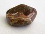 Identifying Lake Superior Agates and Beach Rocks.
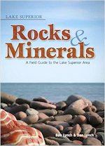
See Our Reviews of the best guides to Lake Superior Agates and Beach Rocks.

)

See our
Reviews of best Ontario golf courses around Lake Superior.