Michigan UP Lake Superior Circle Tour Travel Planner
Munising, Grand Marais to Tahquamenon Falls, Michigan
Michigan Upper Peninsula Travel


Grand Marais & Pictured Rocks National Lakeshore – eastern side
Pictured Rocks Website: www.nps.gov/piro/
From Munising, it is possible to go directly to Grand Marais along the southern edge of Pictured Rocks National Lakeshore via County Hwy H58. It is an attractive drive during fall color time and provides access to three Pictured Rocks campgrounds along this route.
The alternate route follows more major highways and travels a few more miles to see the other side of Pictured Rocks near Grand Marais. Take Hwy 28 east out of Munising 36 miles to the intersection of Hwy 77 and the village of Seney. A worthwhile short side trip is the Seney National Wildlife Refuge 5 miles south via Hwy 77. There’s an informative visitor center, hiking trails, and a nice driving nature trail. Figure at least an hour for this side trip. Returning to the village of Seney, go north on Hwy 77 for 24 miles to Grand Marais – gateway to the east side of Pictured Rocks. There you can explore the Grand Sable Dunes and the eastern section of the park. Figure 1 – 2 hours to get here, depending upon visiting the Seney Wildlife Refuge or not. Then figure another 2 hours to see some of the Pictured Rocks park.
Besides the campgrounds in the National Park. the town of Grand Marais offers a 110 unit campground on the lake, with full hookups (Woodland Park).
Recommended places and things to do:
-
Grand Sable Visitor Center
-
Sable Falls and Grand Sable Dunes
-
Log Slide Overlook hiking trail
-
A more ambitious hike would be the trail to the Au Sable Light station from the Hurricane River Campground.
Grand Marais to Tahquamenon Falls (see pictures & more info here)
Here you have another choice of sand road vs paved road. H58 continues east of Grand Marais, running close to the lakeshore at times. Down side it is a sand road. If you elect this route and are camping, you may be interested in the National Forest campground that is right on the lake – about 11 miles east of Grand Marais. No electric hookups but a terrific view of the lake and your own sand beach.
In another 6 miles is Muskellonge Lake State park; it does have RV hookups and a dump station. Muskellonge is also has a great rock picking beach and is the site of the annual Lake Superior Agate Festival.
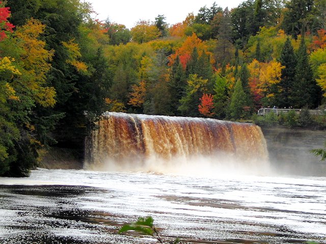
But most travelers will probably opt for the paved road, returning south on Hwy 77 24 miles to Seney. From there its Hwy 28 east about 25 miles to the town of Newberry (on Hwy 123 north). It’s about another 25 miles to Tahquamenon Falls State Park. So figure 90 minutes to get from Grand Marais to Tahquamenon Falls.
The Upper and Lower Falls are separated by 4 miles. The campground is by the lower falls. Non-campers can find accommodations in the village of Paradise 12 miles east on Hwy 123. 5 miles south of Paradise is the riverside campground unit of Tahquamenon Falls park. If you are not camping here overnight, plan to spend 2 – 4 hours hiking around the park.
Recommended places and things to do at Tahquamenon Falls:
-
Upper Falls Scenic Overlook
-
Tahquamenon Falls BrewPub
-
Lower Falls Boardwalk Trail
-
Boats and canoes are available for rental in the lake below the lower falls
-
If adequate time and ambition, hike the Tahquamenon River Trail (4 miles)