|
The Road to Vista Lake: The Morgan Lake Trail
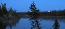
The first round of research was done. Vista Lake was our destination. A clean, clear lake framed by high bluffs, with four long arms of water in the shape of a cross. Good fishing reports. Now our decision was how to best get in there.
Most of the guide books suggest a route from Poplar Lake, adjacent to the Gunflint Trail. Petie didn't like the looks of that way in: "Lots of portages, how bad are they?" he inquired. Didn't know but I thought I'd add up the total rods just to get an idea of the length. While I was pulling numbers off the map, I noticed a dotted line running west from Forest Highway 315 all the way to Morgan Lake - which was only a short portage from Vista. Curious, wonder what the dotted line signified? I checked some other maps and guide books. Discovered the dotted line had a name: Morgan Lake Trail. Hmn, must be something more than a portage trail; it has a name.
So I put Petie onto this new possibility and we both tried to find out more information on the trail. We were separated by 300 miles, so our conversations were on the phone and through the mail. We each seemed to have only fragments of information and some hunches - which we shared with one another. Finally a convincing picture began to take shape in our minds eye. At one time - in the pre BWCA days - the trail was a road to Morgan Lake. But now it has shrunk back to a trail - possibly used by horses. So we weighed our alternatives. We could take one long, but easy walking portage of about a mile via the Morgan Lake Trail or we could take several shorter portages that totaled about the same length - but were of unknown difficulty. Adding to the negatives of the traditional access route was a longer, circuitous paddle over several lakes. We chose the Morgan Lake Trail.
Our rendezvous was in the twin cities where we secured our BWCA permit to enter at Morgan Lake and then we headed north. We stayed that evening at the Flour Lake campground off the Gunflint Trail. After dinner Petie starts chuckling and reaches in his truck to show me his latest "invention." He had modified a golf cart to serve as a canoe and luggage carrier. He figured to trot down the Morgan Lake Trail in fine style! I didn't have the heart to instantly deflate his pleasure by telling him about the BWCA "no wheels on portage trail" policy. Figured I'd deal with that in the morning at trail side.
So after breakfast the next morning, we charged down FH 315 to begin our adventure. My buddy Kurt was driving his van; I was navigator. Petie and Bob followed in Bob's truck. I had my eyes peeled for one of those brown and yellow forest service signs - saying "Morgan Lake Trail" or perhaps "Parking" or something like that. After a while it was clear I somehow missed the trail sign. We had gone too far south. So we did a U turn and the caravan headed north, with me doing less talking and more looking this time. Amazingly we seemed to have missed it again. So we stopped and had a pow-wow in the middle of FH 315. We drug out the maps and determined we were near where the Brule River crosses the road. Great, a definite marker. So I plotted that the MLT was about a half mile down the road. This time we're doing an odometer reading. Off we headed.
At the half mile point, I had Kurt slow to a 5 mph crawl. Up ahead I saw that the shoulder of the road spread out a bit providing just enough room for a car to pull off the road. I suggested we stop there. Bob and Petie pull up and say "Is this it?", incredulously as there wasn't much "it" apparent! I replied "dunno" and suggested they continue down the road a piece to see if anything looked more promising. Shortly they returned - nadda. So we climb out and start looking around. We spot a deer path going through the brush and reeds that heads in the right direction. Petie's on my case big time: "This piss ant slash in the woods can't be the Morgan Lake trail." I say it has to be, its in the right place and the only thing we've found. "It probably gets better as we get away from the road," I assure the assembled crew. So we do it. Bob grabs a back pack and charges on down the path while the rest of us are unloading the canoe and gear.
I was watching Bob out of the corner of my eye as he went deeper into the brush. All of sudden I saw him shrink 2 feet and yell out "damn water!" But he kept on going. Meanwhile the wheels are turning in my head as we unload - this is going to be a long and not necessarily easy portage. A few minutes later Bob has returned shaking his head. "Found another swamp and it looks pretty bad. I don't know about you guys, but I think it's a lost cause." Well, guess that's it for the Morgan Lake Trail. Time for Plan B.
After consulting our maps, Plan B turned out to be back to the Brule River where it went under the road. The map shows it connects into Horseshoe Lake, which is only one short portage from Vista. While it looked like a few portages might be needed where the river narrows, it definitely seemed to be a better choice than the MLT! So the Voyageurs soon were on their way paddling up the Brule.The sun was shining, life was good. About a half mile later the river depth shrank to a foot or two and then we came to a small rapids. Kurt and I elected to portage around it. Bob and Petie decided to drag their canoe up the rapids. Some aluminum was left in the river decorating a few rocks. But hey, they didn't have to portage and Petie hates portages!
 I should mention here that my friend Petie has lots of fishing and camping toys - most of which manage to accompany him on an outing. So "old betsy" the big SmokerCraft canoe was loaded down with folding lawn chairs, several fishing rods, an extra tackle box, and other "just in case" stuff. This helps explain why Petie doesn't like to portage. I should mention here that my friend Petie has lots of fishing and camping toys - most of which manage to accompany him on an outing. So "old betsy" the big SmokerCraft canoe was loaded down with folding lawn chairs, several fishing rods, an extra tackle box, and other "just in case" stuff. This helps explain why Petie doesn't like to portage.
Good thing the sun was shining. Turned out Plan B had 12 more portages around rapids, beaver dams, and places where the stream just wouldn't float a canoe. Bob and Petie beat themselves to death dragging the canoe. It now became a principle, no portages! My canoe mate Kurt is Petie's opposite. He's one of those minimalist canoe-campers. His fishing tackle box fits in his pocket; he counts ounces in planning for a trip. So our portages weren't bad. They were short and we got in a routine of loading and unloading the canoe. Yet with 13 portages and carries, by the time the river finally opened up into Horseshoe Lake, we had understood why the guide books failed to mention our great discovery as an alternate route into Vista Lake!
The sun was still shining as we cruised into Vista Lake. We found a nice campsite at the end of the western arm of the lake. We got the tents set up, the kitchen area organized . . . including a "just in case" tarp strung over the eating area to keep things dry in case of rain. We found a good tree to hoist up the grub sack out of the reach of bears. Even had time for some fishing before dinner. After dinner we sat around the fire laughing about the day's experience. We triumphed over adversity (of our own doing), life was good. A toast to our health and good fellowship and we were off to bed.
In the middle of the night, the sky exploded with lighting and buckets of rain. If a tree didn't fall on us, Kurt and I figured to get swept away by the river that was now running by our tent. But fortunately we made it through the night. The next morning we discovered Petie and Bob weren't as lucky. They had pitched their tent on a reasonably flat spot, however it was that way because it was the filled in V between two opposing hillsides. So guess where all the water ran off those hillsides - right through their tent. Fortunately Petie had brought cots as part of his comfort regimen. Had they been on sleeping pads like Kurt and I they would have been soaked.
The rain continued for most of the next three days. In brief interludes we did some fishing, caught a few smallies and one northern. But most of time was spent keeping a fire going under the tarp. We had an assembly line of wood cued up around the fire to dry and then a few flanks of wet wood waiting their turn closer to the fire. The last stage of a stick of wood prior to burning was cooking on the top of the fire grate. With this firewood processing system we kept reasonably warm and dry under the shelter system of two tarps we set up over the cooking area. And the Yukon Jack was especially tasty.
In addition to some fishing, we did a little exploring. Hiked up to Misquah Lake, a deep pocket of water at the top of a high point in the area. Horseshoe Lake supposedly has good fishing. It needs that as a strength because it is on the ugly duckling side as far as looks go. Saw some moose in the long grass by shore. Were able to paddle pretty to close to him before he decided to go. Morgan Lake is a pretty little lake, with some good looking fishing structure. Supposed to have some nice bluegill. We didn't catch anything.
On the last day, we broke camp in the morning in light drizzle. As we cruised through Horseshoe Lake and then down the wider part of the Brule River, we found a pleasant side benefit of all the rain we experienced. Kurt and I had a ball shooting the rain-swollen rapids in his Old Towne Penobscot. I think we only had to do one portage on the way out. Petie and Bob weren't so lucky. The laden down SmokerCraft seemed to have a talent for getting hung up on rocks. Lots of cussing, teamwork breaking down. The final blow came after getting hung up sideways in some fast moving water - a total dunking. Our guys were not happy campers. Kurt and I helped collect all the stuff swept downstream. Nothing lost, just wet. Fortunately that was the last of the rapids and beaver dams. The river widened and deepened from that point on. And almost on cue, two minutes after getting the guys loaded and back into their canoes, the sun breaks out just like it was on the way in. In fifteen minutes their clothes are drying, everyone is singing voyageur songs, and it's smooth paddling all the way back to our vehicles.
We loaded up and headed to the Harbor Light in Grand Marais where tasty burgers awaited us . . . finished off with pitchers of Leinenkugels. We had great fun replaying the scenes from the previous five days. All of the downers were now uppers. Throughout the adversity, we remained four comrades refusing to let fate keep us from having a good time and enjoying one another's company. For this reason, the Road to Vista Lake: the Morgan Lake Trail will be remembered among the best of our BWCA adventures.
But if you go, I suggest access points 47 or 48, not the mythical Morgan Lake Trail . . . and make sure to pay close attention to the maps to insure your imagination doesn't create what isn't there!
-Ross Reinhold, Mt. Horeb, Wisconsin
|