Temperance River State Park
2 Miles Southwest of Tofte, Mn
Attractions |
Facility Information |
- Waterfalls and cascades on the Temperance River
- 22 miles of hiking trails
- Wayside parking lot on Hwy 61.
- Full Service Campground
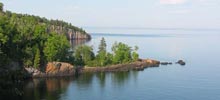
- Lake Superior Beach
- Day Use Picnic Area
- Lake Superior Overlooks
- Winter: cross-country skiing, snowshoe trails, and snowmobile trails
|
- 55 camp sites (18 w/ electric hookups)
- 18 cart-in sites
- Some electric sites also open in winter
- 4 back country cabins, 1 lodge
- No RV dump station
- Showers and flush toilets (seasonal)
- 218-663-7476
- www.dnr.state.mn.us/state_parks/temperance_river
|
Park Hiking Trail Map
- Superior & River Overlook Loop - 0.3 miles
- Hidden Falls Loop - 0.5 miles
- Cascades - 2 miles round trip
- Carlton Peak Trail - 6.2 miles round trip
(a shorter trail is available off Cty Rd. 2, Britton Peak parking lot)

|
)