Ontario Lake Superior Circle Tour Travel Planner
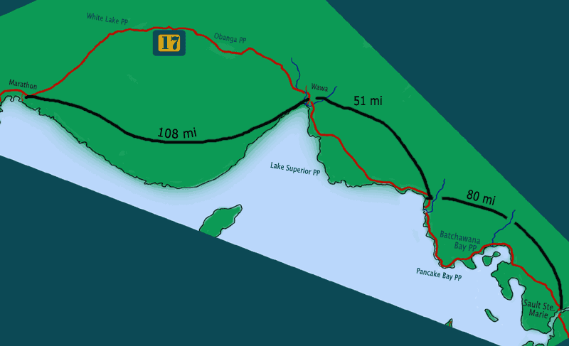
Sault Ste. Marie to Lake Superior Provincial Park
Ontario Canada
Ontario North Shore Travel
Sault Sainte Marie, Ontario (see pictures & more info here)
Tourism Website: www.sault-canada.com
If you cross the International Bridge on a weekend or holiday, be aware you could easily require a half hour or more just to go a few miles. One bonus of the delay is that you have time to get a nice aerial view of the locks and the river!
The Ontario Sault Ste. Marie is one of the three larger cities on Lake Superior (along with Duluth, Mn and Thunder Bay, Ontario). It is also one of the oldest communities in the upper midwest. Like Duluth and Thunder Bay, Sault Ste. Marie has a lake walk – only in this case it is more accurately a river walk. It extends 1.5 km from Canal Drive to the Civic Center.
The “Soo” has a number of quality chain motels with familiar names: Best Western, Comfort Inn, Days Inn, Holiday Inn, Super 8, Travelodge, etc. As it is five times the size of its US twin, it offers many more lodging, dining and entertainment choices. Your first stop after crossing the bridge should be at the tourist information center (turn right on Huron St. and go towards the river). Nearby are a number of attractions in the downtown area along the river front. Plan to spend at least 2-4 hours along the Boardwalk and Canal-Locks Park. You’ll need a whole day if you do the Agawa Canyon Tour train.
Recommended places and things to do in Sault Sainte Marie, Michigan:
- The Sault Ste. Marie Canal and Locks, a National Historic Site. Tours, exhibits, and structures dating back to 1895
- St. Mary’s Island Nature Preserve and Hiking Trails.
- The 1.5 km Riverside Boardwalk, Roberta Bondar Waterfront Park & Pavilion, and riverfront hospitality establishments
- Excursion Boats and Lock Tour Cruises
- Agawa Canyon Tour Train
- Hiawatha Park and Crystal Falls (for hikers and waterfall explorers)
Our favorite Soo area campground is Point Des Chenes Park about 10 miles west of the city on Whitefish Bay. Two other camping facilities are at the northern edge of the city off highway 17.
Restaurant Review – Boots & Saddles Roadhouse
The Roadhouse is several miles west of town on Highway 550 near the International Airport. We stopped there because we were camping nearby at Point Des Chenes.
I had a steak and veggie stir fry; Jo was in the mood for a deluxe burger. Ample portion size, tasty, the right temperature. Amiable waitress staff. Had to wait longer than expected for the meal to arrive but when it came, it was hot and properly prepared. Reasonable prices. As name suggests, it has a western motif and a “beefy” menu. Bar area separate and elevated. Noticed no problem with cigarette smoke – one of Jo’s pet peeves.***stars
Dockside Riverfront Grill & Restaurant
This downtown area restaurant is along the Riverfront Walkway with good views of the water and a choice of dining indoors or out on their deck. We had lunch there, Jo choosing a mushroom & swiss burger and me their Reuben, with a nice ice-cold 20 oz schooner of Molson Canadian. Sandwiches were good; service, friendly but inattentive. Our particular wait staffer was young and new and it was early-season for outdoor dining. We liked the place enough to want to return for dinner sometime. ***stars
Traveling North of Sault Sainte Marie, Ontario
Go Here for our Provincial Parks & Lake Superior Camping Directory
Taking Hwy 17 north, it’s 29 miles to the Chippewa River rest stop where you can see the falls from the bridge. From the wayside picnic area, there’s a hiking trail leading to the top of falls and beyond. Batchwana Bay Provincial Park is another 7 miles. It offers an expansive sand beach for swimming, sunbathing, and beach combing. Also picnic areas. No camping as it is a day use area only. Pancake Bay Provincial Park, another 6 miles down the road, offers a similar expansive sand beach and 325 camping sites, including 160 with electrical hookups. Most sites have a view of the lake or catch a nice breeze off the lake (worthwhile during the buggy season or when it is hot). It’s about another 35 miles to the southern entrance to Lake Superior Provincial Park; there are 3 campgrounds in the park. Non-campers have a number of motel and resort options in the Batchawana Bay area. Non-campers who didn’t spend several hours in Sault Ste. Marie can travel through Lake Superior Provincial Park (1 – 3 hours depending on stops) and find many lodging and dining choices in the Wawa area.