Michigan UP Lake Superior Circle Tour Travel Planner
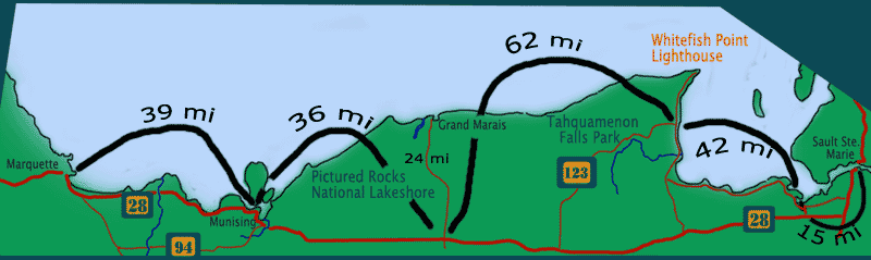
Scenic Drive Tahquamenon Falls State Park to Munising, Michigan
Michigan Upper Peninsula Travel
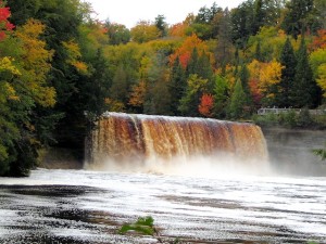
Tahquamenon Falls State Park
The Upper and Lower Falls at the park are separated by 4 miles. The campground is by the lower falls. Non-campers can find accommodations in the village of Paradise 12 miles east on Hwy 123. 5 miles south of Paradise is the riverside campground unit of Tahquamenon Falls park. If you are not camping here overnight, plan to spend 2 – 4 hours hiking around the park.
Recommended places and things to do at Tahquamenon Falls State Park:
- Upper Falls Scenic Overlook
- Tahquamenon Falls BrewPub
- Lower Falls Boardwalk Trail
- Boats and canoes are available for rental in the lake below the lower falls
- If adequate time and ambition, Tahquamenon River Trail (4 miles)
Links:
Tahquamenon Falls State Park (see pictures & more info here)
Going West Traveling to Grand Marais (see pictures & more info here)
From Tahquamenon Falls, Take Hwy 123 west and south to the town of Newberry. Just south of Newberry you’ll intersect with Hwy 28. Take it west towards the town of Seney. There you take highway 77 north to Grand Marais.
A worthwhile short side trip is the Seney National Wildlife Refuge 5 miles south via Hwy 77. There’s an informative visitor center, hiking trails, and a nice driving nature trail. Figure at least an hour for this side trip. Returning to the village of Seney, go north on Hwy 77 for 24 miles to Grand Marais – gateway to the east side of Pictured Rocks.
Grand Marais, Michigan
Grand Marais & Pictured Rocks National Lakeshore – eastern side
Pictured Rocks Website: www.nps.gov/piro/

Once in Grand Marais you can explore the Grand Sable Dunes and the eastern section of the National Lakeshore Park. Figure at least 2 hours to see some of the Pictured Rocks park.
Besides the campgrounds in the National Park. the town of Grand Marais offers a 110-unit campground on the lake, with full hookups (Woodland Park).
Recommended places and things to do:
- Grand Sable Visitor Center
- Sable Falls and Grand Sable Dunes
- Log Slide Overlook hiking trail
- A more ambitious hike would be the trail to the Au Sable Light station from the Hurricane River Campground.
To continue your travels, either take County Hwy 58 west through Pictured Rocks Park or go south again on Highway 77 towards Seney. There intersect with Hwy 28 and proceed west 36 miles to Munising.
Links:
Campgrounds Tahquamenon Falls to Grand Marais